The temperature field that misses the daily high
A five-station NOAA study shows how temperature fields and reporting windows differ from the daily high used by weather contracts.
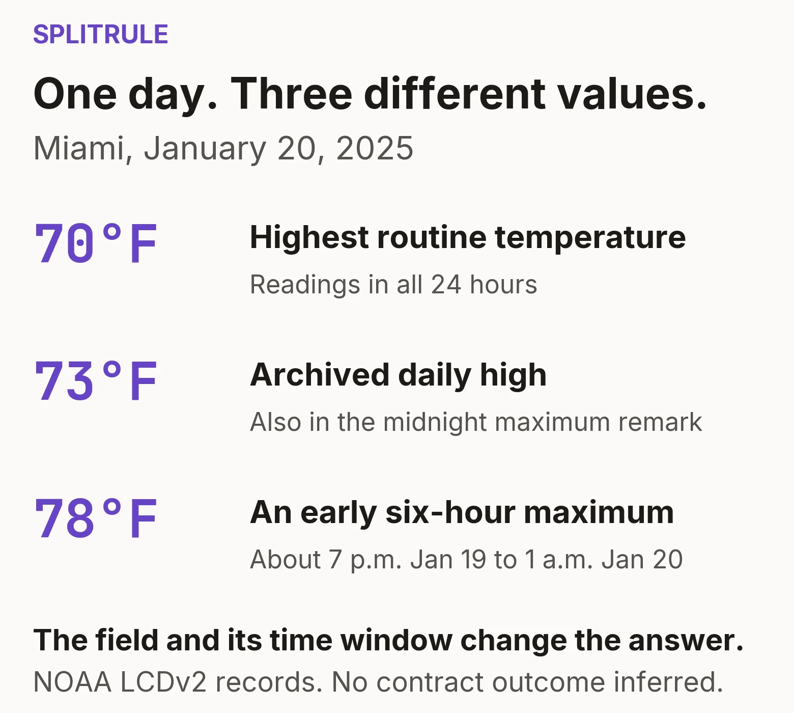
Miami’s routine temperature readings reached 70°F on January 20, 2025. NOAA’s archived daily high was 73°F. There was a routine reading in every hour.
For a temperature contract, that difference can matter. Polymarket US names Miami International Airport as its Miami station and the National Weather Service’s Daily Climate Report as its settlement source. A chart of that station’s hourly temperatures does not necessarily show the value in that report. PM-US weather FAQ
But “hourly data misses the high” is too broad. The same Miami archive contains a midnight report with a separate maximum-temperature remark of 73°F. The information was there, in a different field.
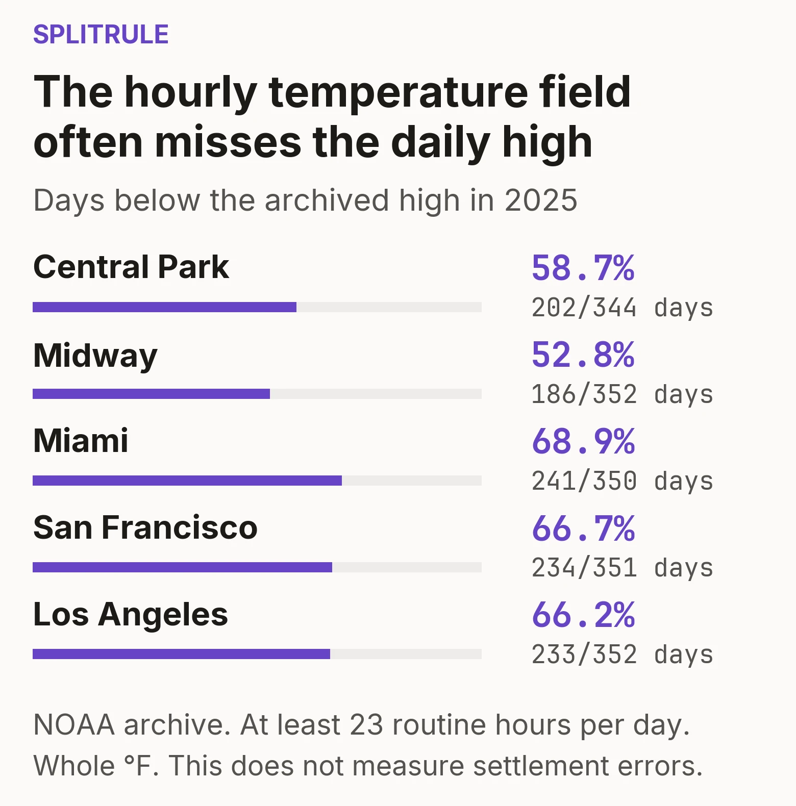
How often did the fields differ?
I compared a full year of NOAA records at all five stations in the current PM-US weather FAQ. Those are Central Park, Midway, Miami International, San Francisco International and Los Angeles International.
For each eligible date, I compared the highest routine current-temperature reading with the archived daily maximum. I converted both to whole degrees Fahrenheit. Each date needed readings in at least 23 distinct hours, plus checks for conflicting records and inconsistent timestamps.
The daily maximum exceeded the highest routine reading on 202 of 344 dates at Central Park and 186 of 352 at Midway. Miami reached 241 of 350, San Francisco 234 of 351, and Los Angeles 233 of 352.
That is about 53% to 69%, depending on the station. The usual positive difference was 1°F. Gaps of 2°F or more occurred on 6% to 15% of eligible dates, by station. Restricting the comparison to dates with readings in all 24 hours barely changed those percentages. Missing an entire hour does not explain the result.
These are comparisons within NOAA’s historical archive. They are not counts of incorrect settlements. Two dates also ran in the opposite direction: the routine reading exceeded the archived high. The methods retain those cases and disclose the data checks. Data and methods
The report contains more than one temperature
A routine METAR is a weather report at a particular time. Its current-temperature field describes conditions around that observation. The daily high can occur between those observations. In the Miami example, the highest routine reading, 70°F, came at 12:53 a.m. The archived daily high does not record when the 73°F occurred.
Some METARs also contain maximum-temperature remarks. Six-hour maxima appear in reports associated with 00, 06, 12 and 18 UTC. A separate daily maximum appears in the local-midnight report. Those values answer different questions from the current-temperature field. ASOS manual, section 3.1.2
The difference is large in this sample. On dates with an eligible midnight maximum remark, that remark matched the archived daily high on over 99% of dates at each station. At Midway, for example, the current-temperature maximum matched on 165 of 351 dates. The midnight maximum remark matched on 348 of those same 351 dates.
That comparison uses the same dates for both fields.
A maximum remark still has limits. The midnight report usually leaves a few minutes before the climate day ends. The archive also contains conflicting values, including eight disagreements between midnight remarks and daily highs across the five stations. These remarks are useful evidence, but they do not replace the contract’s named report. The PM-US FAQ names the 24-hour METAR observation as a cross-check. If the CLI reading is inconsistent with it, settlement can be delayed until 11 a.m. ET for review. PM-US weather FAQ, ASOS manual, methods
A maximum also needs a time window
The Miami example contains a third value. At 12:53 a.m. local standard time on January 20, a six-hour remark reported 78°F. Its window runs from about 7 p.m. on January 19 to 1 a.m. on January 20. A 6:53 p.m. reading on January 19 also showed 78°F. Assigning that entire maximum to January 20 because of the report’s date gives the wrong window.
The climate day follows local standard time throughout the year. During daylight saving time, midnight-to-midnight standard time corresponds to 1 a.m. to 1 a.m. on the local clock. A midnight cutoff in a chart can therefore select the wrong period. NWS climate instruction, section 4.1.2
Start with the contract’s report
The PM-US FAQ links Miami to the NWS CLIMIA report. The copy retrieved on October 4 reported a maximum of 87°F for October 3. Its heading identified the date, and its temperature table identified Fahrenheit. NWS Miami CLI
The filed contract template distinguishes “above” from “at least.” Applied to 87°F, an illustrative “above 87°F” condition is false, while “at least 87°F” is true. These are examples of the operators, not claims about an actual listed contract or its settlement. PM-US temperature terms
The particular contract also determines which publication counts as final. NWS climate reports are preliminary and can change through later quality control. A subsequently downloaded NOAA archive is not proof of the value originally used for settlement. NWS observations FAQ
For a daily temperature contract, verify the station, field, observation period, report version and comparison operator. More frequent readings help only when they measure the quantity the contract asks about.
The reporting distinction is established. This study measures it at five stations in 2025. See Splitrule’s data and methods.